Height
The Kotor launch starts from 1256 m on the Lovcen slope, giving the route a high coastal perspective before the descent becomes local.
Decide whether Kotor's enclosed Bay view is the reason to move from scenic curiosity to practical route details.
The Kotor launch starts from 1256 m on the Lovcen slope, giving the route a high coastal perspective before the descent becomes local.
The Bay of Kotor is fjord-like in visual shape, with steep mountain walls and inner bays, though Boka Kotorska is not a classic glacier-formed fjord.
The route passes over St John Fortress and the Old Town before descending toward the bay shore.
View anatomy
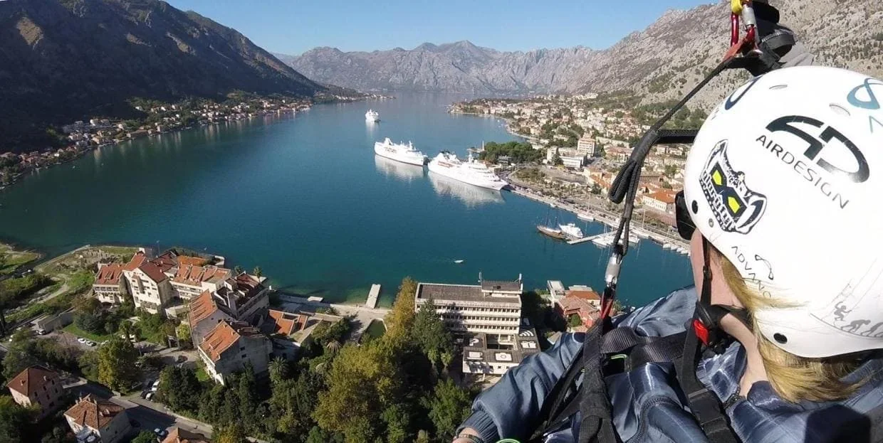
From above Kotor, the view does not spread out like a broad open coast. The Bay gathers the route around height, enclosed water, landmarks and careful scenic claims.
The route opens high above the Bay, so mountains, water and town context are visible before the descent becomes local.
Water sits between steep slopes and inner bays, which keeps the view tied to one recognizable place.
St John Fortress, red roofs and the bay shore become easier to read as the route descends.
Kotor is strongest when the Bay itself is the reason, not when someone wants a broad Montenegro view ranking.
Choose Kotor when the enclosed Bay view, fortress line and Old Town descent are the reason. Choose Budva when town-base logistics, open-coast orientation or resort-adjacent access matter more. Neither page promises a neutral national winner; compare fit before contact.
No. Kotor is strongest when someone wants one compact Bay view with mountains, water, fortress and town together, rather than a broad open-coast sweep.
The enclosed shape keeps mountains, water, Old Town and fortress line legible as one place instead of spreading the view across a wide shoreline.
It is often described as fjord-like because it is enclosed by steep mountain walls and inner bays, but Boka Kotorska is not a classic glacier-formed fjord.
Compare broader scenic moods first if you are not sure about the Bay. Choose Kotor when the enclosed Bay, St John Fortress and Old Town are the reason you want the route.
After the general Kotor answer, the question is no longer whether there is a route here. The useful question is whether this enclosed Bay view is the right reason to choose it.
Some coastal flights feel wide, bright and open. Kotor is different: the view narrows around the Bay, old stone and mountain walls. For the local pilot team, that makes the route a clear Bay demonstration rather than another broad scenic promise.
The moment after takeoff is the clearest difference: the ground drops away, the Bay sits below, and old stone, water and the fortress line stay in the same descent. The result is not just “a nice view”. It is a high scenic descent into a place that remains readable from the air.
The launch on the Lovcen slope is at 1256 m above sea level. That height matters because the route does not feel like a short lift above a beach. It opens with a wide mountain-and-bay perspective, then gradually descends toward the water and the town.
The Bay of Kotor is often described as fjord-like because of its enclosed shape, steep mountain walls, narrow passages and inner bays.
That description is useful visually, but it needs care. Geologically, Boka Kotorska is not a classic glacier-formed fjord. For the tandem paragliding experience, the important point is the shape: water held tightly between mountains, with the Old Town, stone slopes and fortress close together in the frame.
That enclosed form is why Kotor can feel more specific than a broader open-coast view: the route does not ask you to admire “Montenegro” in general. It keeps bringing the eye back to one Bay.
At higher altitude, the Bay, mountains and open airspace dominate. Lower down, the fortress and Old Town become especially legible: red roofs larger in the frame, the fortress line clearer, and the landing context near the shore starting to make practical sense.
This is what Kotor can honestly offer visually: not a guaranteed weather mood, not a universal scenic ranking, but a route tied to one of the Adriatic coast’s most recognizable places.
That does not make Kotor automatically better for every traveler. It means Kotor is stronger when the person wants the Bay itself: the mountain walls, old stone, water, fortress and city as one connected aerial frame.
If the real question is still which scenic mood fits best, use the scenic comparison first. If the Bay is the view you want, continue to the practical Kotor details.
Basis: local route elevation reference, page image set, Kotor landmark framing and bounded Bay-shape wording. Fjord-like is used as visual shape language, not as a geological classification.
Scenic wording should be reviewed when comparison logic, images or route framing changes materially.
Bay view fit
If this enclosed Bay view is the one you want, the next useful step is practical: timing, fee, participant suitability and weather limits for the Kotor route.
Before you reach out