
Local team
Local tandem pilots flying the Lovćen route above Kotor and the Bay.
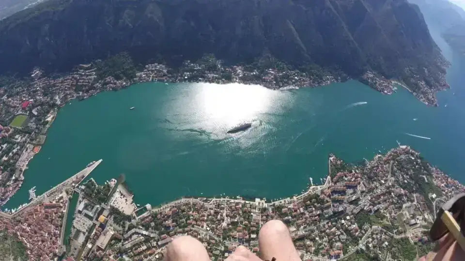
Fly from the Lovćen slope at 1256 m, with the Bay, St John Fortress and Kotor Old Town below when conditions allow. No previous paragliding experience is needed; your pilot handles the wing and guides you through the flight.
Local tandem pilots flying the Lovćen route above Kotor and the Bay.
The current tandem flight fee is €155 per participant. A message is an enquiry; the flight still depends on the day and the pilot's final decision.
Optional pilot GoPro video is €10. After a successful recording, you receive the SD card after the flight or a download link when the files are ready.
How the Kotor flight day works
A typical local flight day: meet in Kotor, drive up to the 1256 m launch, prepare with your pilot, fly when conditions allow, and return to the bay shore.
Once the day looks workable, we confirm the practical meeting point and timing in Kotor.
Mountain access from Kotor to the Lovćen-slope launch usually takes about 40 minutes.
At launch, your pilot prepares the equipment and explains exactly what you need to do for takeoff.
Your tandem pilot checks wind, cloud, visibility, lift, takeoff and landing conditions before making the final call.
When lift allows, airtime can reach about 25 minutes above the enclosed Bay and Kotor landmarks.
The normal route finishes near the bay shore around Small Beach; the pilot can change the landing plan if conditions require it.
The current tandem flight fee is €155 per participant. A message is an enquiry, not automatic confirmation: weather, pilot availability, access, equipment fit and the final conditions check still decide the flight.
Yes. Pilot GoPro video is optional at €10. After a successful recording, you receive the SD card after the flight or a download link when the files are ready.
No. Most tandem passengers can fly without previous paragliding experience. Your pilot controls the wing and explains the few things you need to do for takeoff and landing.
The route starts from the Lovćen slope at 1256 m above sea level. The high launch opens over the enclosed Bay of Kotor, with the Old Town and St John Fortress below when visibility allows.
Airtime can be up to about 25 minutes when thermals give enough lift. Conditions can make the flight shorter, so the exact time in the air is never fixed in advance.
Allow up to about 90 minutes for the usual cycle: meeting, mountain access, preparation, the flight and landing. Traffic, wind and waiting at launch can change the timing.
The normal Kotor route finishes near the bay shore by the Small Beach area. The pilot can change the landing plan if the conditions require it.
You can tell us your preferred day or time window, but paragliding is weather-dependent. We confirm the practical plan only when the current conditions and pilot availability line up.
The Bay keeps water, steep mountain walls, Kotor Old Town and the fortress close together beneath the route. It feels compact and unmistakably tied to Kotor rather than like a broad open-coast panorama.
No. This is tandem paragliding from a mountain launch with a pilot. Parasailing is boat-towed from the water, and skydiving starts from an aircraft.
We are a local tandem paragliding team flying the Lovćen route above Kotor and the Bay of Kotor.
The place does most of the talking. You start high above the enclosed Bay, with steep mountain walls around the water. As the flight comes lower, Kotor Old Town, St John Fortress and the shore become easier to read beneath you.
If this is your first tandem flight, that is normal. Your pilot prepares the equipment, explains the takeoff and landing, controls the wing throughout the flight, and makes the final call on whether the conditions are suitable.
That is the current flight fee for one participant.
Pilot GoPro video is optional at €10. After a successful recording, you receive the SD card after the flight or a download link when the files are ready.
Video is optional. Wind, cloud, visibility, takeoff and landing conditions, and the pilot’s judgment always come first.
The Kotor route starts from the Lovćen slope at 1256 m above sea level. Mountain access from bay level is usually about 40 minutes, followed by roughly 10–15 minutes for equipment, briefing and the final conditions check.
When lift allows, airtime can reach about 25 minutes. On weaker days the flight can be shorter even when the route is safe to fly.
The normal descent finishes near the bay shore around the Small Beach area, a short walk from Kotor Old Town.
Tandem means you fly together with a pilot. You do not need to know how to control the paraglider.
Before takeoff, your pilot fits the harness and helmet and gives you a short briefing. Your main job is to follow a few clear instructions, move forward confidently at launch, then sit back and enjoy the flight once you are airborne.
Wear secure closed shoes and clothes that make sense for the season. The launch can feel noticeably cooler than Kotor town.
Kotor is a high, enclosed-Bay route. Wind, cloud, precipitation, thermal lift, visibility and launch access can change the plan even when the waterfront looks calm.
We can discuss a preferred day or time window, but we do not turn that into a guaranteed slot. The tandem pilot makes the final go/no-go decision from the real conditions.
If the Bay is the reason you want to fly, Kotor is a special place to do it. If the weather says no, we do not force the route.
Basis: current Kotor route facts and the 2026-10-07 local-pilot-team operational layer.
Weather, access, pilot availability, equipment fit and launch or landing conditions can change the plan. A flight enquiry is not automatic confirmation.
Kotor flight enquiry
Tell us your preferred day or date range and how many people want to fly. We will reply with the practical details; final confirmation still depends on current weather, pilot availability, access and the conditions at launch.
Before you ask about a flight